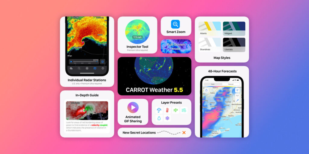
Αφού κέρδισε τόσο το Βραβείο Σχεδιασμού της Apple όσο και το Βραβείο Εφαρμογής της Χρονιάς πέρυσι, το Carrot Weather έφερε την πρώτη του σημαντική ενημέρωση για το 2022. Η έκδοση αυτή φέρνει μια ανακατασκευασμένη και ταχύτερη από ποτέ εμπειρία χαρτών καιρού, επίπεδα για προβλέψεις, πρόσβαση σε μεμονωμένους σταθμούς ραντάρ, μια νέα λειτουργία έξυπνου ζουμ και πολλά άλλα.

Η έκδοση συνοδεύεται από μια σταθερή λίστα βελτιώσεων και αλλαγών, συμπεριλαμβανομένων πλήρως ανακατασκευασμένων μετεωρολογικών χαρτών για μια εμπειρία απίστευτης ταχύτητας. Υπάρχουν τώρα 6 διαφορετικά στυλ χάρτη μαζί με μια νέα τρισδιάστατη υδρόγειο.
Τα επίπεδα χαρτών είναι τώρα διαθέσιμα για προβλέψεις (έως 48 ώρες) και ένα νέο εργαλείο επιθεώρησης διευκολύνει την προβολή των ακριβών τιμών των δεδομένων στο χάρτη.
Ακολουθεί το συνοδευτικό κείμενο της αναβάθμισης αυτής:
Release notes:
Winter is in full swing, meatbags! And while you’ve been busy filling your squirrel holes with nuts, I’ve been hard at work on a major overhaul of my weather maps.
New Map Styles
Choose from 6 gorgeous new map styles that strip away distractions so you can focus on what really matters: the data layers on top. Includes support for both Round and Flat Earthers.
Individual Radar Stations
View individual U.S. radar stations, just like a real meteorologist! Individual stations update more frequently and show significantly more detail than the stitched-together mosaic that covers the entire country. Professional meteorologists use this high-quality data for everything from telling rain apart from snow to deciding when to issue tornado warnings, but the good news is you don’t need a meteorology degree to take advantage of everything these stations have to offer. (Premium Ultra required.)
Forecast Map Layers
See up to 48 hours into the future with map layers like precipitation, temperature, wind, and more. (Premium required.)
Inspector Tool
You won’t need to scrutinize a map legend to guess how strong a storm is anymore – now you can use the all-new Inspector tool to display the exact values of the data that appears on the map! (Premium Ultra required.)
Map Presets
Presets group relevant map layers together, making it easy to quickly switch between them without having to turn a bunch of layers off and on.
Smart Zoom
Zoom in to display radar, zoom out to display a short-term forecast, and zoom even further out to display an extended forecast. Zooming also automatically adjusts layer opacity and animation speeds.
Map GIFs and Screenshots
Make all your social media pals jealous of the superstorm that’s heading right for your house – just tap the Share button on the Maps tab to send out a screenshot or an animated GIF!
As if all those new features weren’t enough, I also added 5 new secret locations for you to hunt down, bringing the grand total to 101 secret locations (!).
xoxo,
CARROT
Aκολουθήστε το AppleWorldHellas στο Google News για να ενημερώνεστε άμεσα για όλα τα νέα άρθρα! Όσοι χρησιμοποιείτε υπηρεσία RSS (π.χ. Feedly), μπορείτε να προσθέσετε το AppleWorldHellas στη λίστα σας με αντιγραφή και επικόλληση της διεύθυνσης https://appleworldhellas.com/feed. Ακολουθήστε επίσης το AppleWorldHellas.com σε Facebook, Twitter, Instagram, και YouTube


